  |
  |
The “journey through uncharted waters” – at least for many of the young participants – was intended to encourage children and adolescents to perceive the role of the research vessels and also the investigation of the oceans, and Portuguese maritime heritage as one of the greatest values of the country.
This activity took place from the 13 – 15 may 2013 and was organized within the framework of the WP6 – Advanced Training and Education, Task 6.5 – Education activities under the responsibility of EurOcean and in collaboration with the Center for Environmental Studies and the Sea (CESAM), University of Aveiro.
On board, scientists from the University of Aveiro, in collaboration with researchers of the Center of Oceanography from the University of Lisbon, surprised the little sailors with what science can do for the study of the oceans, and the role of Research Vessels in that scope.
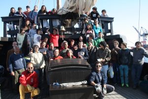
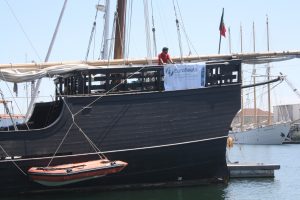
The activities were held on board of Vera Cruz, the replica of a caravel from the sixteenth century belonging to the Portuguese Association of Sail Training.
Students from four cities of the country, with ages between 8-19 years old, met to recognize the importance of oceanographic research vessels, positioning systems and sciences dedicated to oceanographic research, with particular attention to the Marine Geology and Geophysics and Physical Oceanography.
The scientific program of the cruise was organized, by Professor Luís Filipe Menezes, scientist at the Center for Environmental Studies and the Sea (CESAM), University of Aveiro and focused on:
1) Presentation of Key Concepts
- Safety Rules on board;
- Introduction to the history of the “Vera Cruz” Caravel and its importance in the Portuguese discoveries;
- The importance / necessity of Research vessels in Marine Science;
- Introductory concepts of Navigation and Positioning Systems;
- Importance of the study of the Seabed Geology and Sub-surface, in particular what concerns the study of mineral and energy resources, the plate tectonics and geological risks, and archaeological heritage;
- Importance of Physical Oceanography for the study of the physical properties of the ocean, in particular, currents, temperature and salinity, and their implications for ocean-atmosphere interaction;
- Explanation of the geophysical methods, mainly Side Scan Sonar and reflection profiles of High-Resolution seismic – Chirp Sonar;
- Presentation of the methods used in Physical Oceanography to measure the temperature and salinity of the water column (CTD) and currents (current meter).
2) Monitoring of data acquisition during cruise and observation of the
equipment used:
- Real-time acquisition of profiles of side-scan sonar and high resolution seismic of reflection – Chirp Sonar.
- Acquisition in real-time of temperature and salinity profiles (CTD) and current profiles (current meter).
For more Information please consult the following
materials developed specifically for the activity:
- Technical factsheet
- Educational Brochure (only in portuguese)
Related news: